- Screen Colours:
- Normal
- Black & Yellow
Mon
16
Jan
2023
14
30
Mon
16
Jan
2023
16
00
History of Dunwich Heath
The Turbulent History of Dunwich Heath by Richard Symes (NT)
Our January talk was amazing in several ways. We all looked forward to this talk by Richard Symes, and so did a lot of other people. The Fromus Centre meeting room was fuller than we have ever seen or expected — possibly because of interest in Dunwich Heath, and the status of Richard who has researched Dunwich Heath for years.

Richard showed an 1826 hand-painted map of Dunwich showing various features, The German Ocean (the North Sea) including the origin of Dunwich Heath and the Common over hundreds of years from the 1700s. He found a document showing that the Dunwich Town Trust sold permits for the grazing of animals and walking. Gorse and bracken were gathered to keep people warm. The map also showed just how much of the coastline has been taken by the sea.
 |
 |
In 1827 Coastguard cottages were built in an attempt to deal with the big smuggling gangs that worked the area due to a tax on imported goods. The gangs worked with as many as 60-80 horses, with carts, unloading and taking goods all over the country from wrecked trading ships. Officers of the Realm were massively outnumbered. John Harvey ran The Hadley Gang around Sizewell and Dunwich. Harvey was caught and sent to Australia for two years, and when he came back he bought his freedom for a hatful of gold.
The Coastguard Cottages were painted white, showing clearly where help for wrecked ships might come from. As a cottage was decommissioned it was painted black. One occupant, Richard Clark, a Quaker with a wife and five children, was called to fight in the Crimean War. As a Quaker he refused to fight, and was imprisoned on a prison hulk. His case was pleaded in the House of Commons by John Bright MP, and he was released.
At the time of the Industrial Revolution, many ships were bringing iron and coal down the East Coast from the North of England, and many foundered in the area. A Southwold auctioneer, James Maggs, kept a record of the goods and ships which he auctioned. A World War I map of Dunwich and the surrounding area, from Historic Environment Records, shows the sites of shipwrecks all the way along the East Coast. A German map showed how they were using submarines to lay mines on the route of ships bringing iron and coal down the East Coast from the North of England, and many foundered or hit mines. At the end of the war, mines were dragged out of the sea on the end of a rope. After World War II, 30,000 mines were found from Pakefield all the way down the coast.
 |
 |
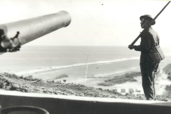
During World War II, concrete blocks were installed along the beach areas (many are still there to this day) and land was flooded to deter possible landings. Germans did attempt to land in Dorset, Shingle Street and Dunwich. Fearing invasion, a whole series of linked radar stations and heavy gun emplacements were set up along the coast, so that planes coming from the sea could be detected and destroyed. In 1960, when the National Trust took over, unexploded ordnance was still being found.
|
Books recommended by Richard Symes: |
 |
|
|
text by Janet Huckle |
This talk has been postponed
from 19th September 2022,
with a change of venue and
now also available over Zoom!
The Turbulent History of Dunwich Heath
—
Three years of research by National Trust volunteer, Richard Symes, uncovered tales of 18th century illegal brandy and tobacco smuggling, revealed the lives of the coastguard families who lived in the cottages during the 19th century and found how First World War trawlermen cleared mines to keep a vital supply route open. Years later the heath would become a militarised zone and one of the most heavily defended parts of Suffolk during the Second World War. The Heath was certainly not always the quiet and peaceful place it is today. [Since 1968, of course, Dunwich Heath & Beach has been a much-loved local asset, cared for by the National Trust.]
Richard visits us at Saxmundham's Fromus Centre on Monday afternoon, 16th January at 2:30pm, to tell us about his exciting project, which has some intriguing links to family history and Leiston as well. As this is at our new venue, we will now be able to offer this as a "hybrid" talk — so over Zoom AND physical — rather than just in-person as originally advertised.
This "hybrid" talk — so over Zoom AND physical — will be at our new venue, Saxmundham's Fromus Centre. Attendees over Zoom should book online in the normal way, but please before 5:00pm on Friday, 13th January, free to Members and at £3.00 for visitors — acknowledgement comprises outline instructions, with information on how to connect 'on the day' emailed to you around an hour before the talk. In-person attendees can just turn up! — at £1.00 for Members, £3.00 for visitors, and with free tea/biscuits.